Where is yosemite national park and how do you get there?
Yosemite National Park is located in the Sierra Nevada mountains of central California, roughly four hours east of San Francisco and six hours north of Los Angeles.
It sits in Tuolumne and Mariposa counties, with the main valley entrance accessible via several routes depending on where you are coming from.
Is Yosemite National Park Worth Visiting?
Yes, and it is one of the few places in the world that earns that answer without any qualification.
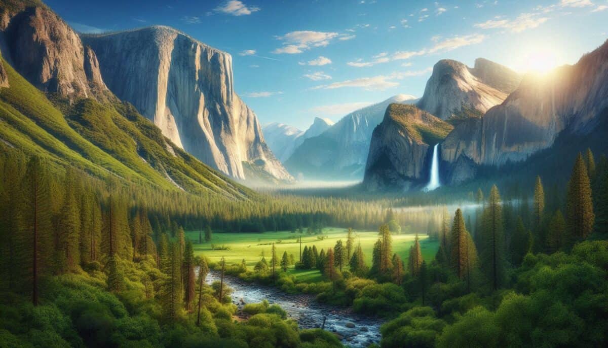
Yosemite National park sits in the Sierra Nevada mountains of central California and covers nearly 748,000 acres of granite domes, old-growth forest, alpine meadows, and some of the most dramatic waterfalls on the continent.
It was the first piece of land in American history set aside by federal government specifically for public use and preservation, signed into protection by Abraham Lincoln in 1864, and formally established as a national park in 1890.
Over four million people visit every year.
That number tells you something. But it also creates a set of challenges that this guide will help you navigate.
How Do You Get There?

Yosemite is located in eastern central California, roughly four hours east of San Francisco and six hours north of Los Angeles.
The closest major airports are Fresno Yosemite International, about 1.5 hours from the valley, and San Francisco International, which is the most common arrival point for international visitors from Canada and Germany.
From San Francisco, the most scenic western entrance is via State Route 140, which follows the Merced River Canyon up into the valley.
For visitors coming from the east, Tioga Road through State Route 120 is open from late spring through fall and offers a completely different experience of the park through Tuolumne Meadows and the high country.
A rental car is the most practical way to get around, but it is not the only option.
YARTS, the Yosemite Area Regional Transportation System, provides scheduled bus service into the valley from Merced, Fresno, Sonora, and Mammoth Lakes.
Once you are inside Yosemite Valley, a free shuttle system covers all major trailheads and viewpoints, which means you can leave your car at your accommodation and move through the valley entirely without driving.
For visitors from Germany or Canada who prefer not to drive on unfamiliar mountain roads, this combination of YARTS and the valley shuttle makes the park genuinely accessible.
What Does It Cost to Enter Yosemite?
The standard vehicle entrance fee is $35, valid for seven consecutive days. Walking or cycling in costs $20 per person.
The America the Beautiful annual interagency pass at $80 covers entrance fees at all federal lands across the United States for twelve months, which is worth purchasing if Yosemite is part of a longer national parks trip.
You can buy the pass in advance at recreation.gov or at the park entrance. During peak summer season from June 15 through August 15 in 2025, a timed entry reservation costing $2 per vehicle is required if entering between 6 a.m. and 2 p.m.
These reservations release on recreation.gov and go quickly.
Check current entry requirements on the official Yosemite National Park website before your visit as the system has changed year to year.
Best Things to Do in Yosemite
Tunnel View
This is the single most iconic viewpoint in the park and one of the most photographed landscapes in all of North America. As you exit the Wawona Tunnel driving into the valley, the entire sweep of Yosemite opens before you:
El Capitan on the left, Bridalveil Fall on the right, Half Dome dead ahead, and the valley floor stretching seven miles into the distance. It costs nothing extra to stop here beyond your entrance fee.
Arrive at sunrise for the best light and smallest crowds. The parking area fills by mid-morning on peak days.
Half Dome
Half Dome is the defining hike of Yosemite and one of the most recognizable granite formations on earth.
The standard route from the valley floor is about 14 to 16 miles round trip with 4,800 feet of elevation gain, finishing with a steep cable-assisted climb up the dome’s curved back face.
A permit is required for the cable section and is distributed through a lottery system. The preseason lottery runs in March and day-of permits become available two days in advance through recreation.gov.
Permits are competitive and demand is high from May through October when the cables are installed.
If you cannot secure a permit, the trail to the base of the cables is still a rewarding hike and gives you close views of the dome without the summit exposure.
El Capitan
At 3,000 feet of sheer vertical granite, El Capitan is the largest exposed granite monolith in the world and the most famous rock climbing destination on the planet.
Even if you are not a climber, watching parties make their multi-day ascent of the wall through binoculars from the meadow below is one of those experiences that changes your sense of what humans are capable of.
The 2018 documentary Free Solo, which follows Alex Honnold’s ropeless ascent of El Capitan, is worth watching before you arrive for context that will transform how you see the wall.
Yosemite Falls
At 2,425 feet from top to bottom, Yosemite Falls is one of the highest waterfalls in the world. The lower falls are accessible on a short paved trail from the valley floor and are impressive even from the base.
The upper falls trail climbs 2,700 feet over 3.4 miles to a viewpoint at the top, and the full loop covering both is about 7.2 miles round trip. Peak flow is in spring from April through June when snowmelt from the high country is at its strongest.
By late summer the falls can slow to a trickle, so spring timing matters significantly if waterfalls are your priority.
Glacier Point
For the most complete panoramic view of Yosemite Valley without a difficult hike, Glacier Point is the answer. The viewpoint sits at 7,214 feet and looks directly across at Half Dome with the full valley and surrounding peaks spread below.
The road to Glacier Point is open from late May through November. You can also reach it by hiking the Four Mile Trail from the valley floor, which is about 4.8 miles one way with 3,200 feet of elevation gain.
Taking the road up and hiking down is a popular option that captures the best of both experiences.
Best Time to Visit
Spring from April through June is the strongest season for waterfalls, wildflowers, and manageable crowds.
The waterfalls are at full force from snowmelt, the valley meadows are green, and temperatures in the valley sit in a comfortable range for hiking. Crowds are building but have not reached their summer intensity.
Summer is the most popular and most challenging season. The park sees its heaviest traffic from late June through August, timed entry reservations are required on most days, parking fills early, and trailheads can feel uncomfortably crowded by midday.
The upside is that all roads and facilities are fully operational, the high country is accessible, and evenings in the valley are genuinely beautiful. Going early in the morning, before 7 a.m., changes the experience dramatically.
Fall from September through November brings cooler temperatures, fewer crowds, and the kind of golden light that photographers specifically plan trips around.
The waterfalls are lower after a dry summer, but the overall quality of the experience is higher for most visitors. October and November are particularly good for anyone whose priority is solitude over spectacle.
Winter from December through March is the quietest season and a genuinely different park. Snow covers the valley floor and coats the granite walls, and the lack of crowds means you can stand at Tunnel View or the base of El Capitan in near silence.
Tioga Road and Glacier Point Road close for winter, limiting access to the valley and Wawona areas. For two weeks in February, a natural phenomenon called Firefall occurs when Horsetail Fall, a small waterfall on the side of El Capitan, catches the last light of sunset and appears to glow like molten lava.
It requires specific conditions including sufficient snowpack and a clear horizon, but when it happens it is one of the most remarkable things you will see in any national park anywhere.
Where to Stay
Staying inside the park puts you in the best possible position logistically. Yosemite Valley Lodge, now called Yosemite Valley Lodge at the Falls, offers straightforward hotel rooms in the heart of the valley.
The Majestic Yosemite Hotel, historically known as the Ahwahnee, is one of the great historic lodges of the American West, opened in 1927 and worth visiting even if you are not staying there. Reservations at both fill months in advance during peak season.
The park also has 13 campgrounds, with high-demand sites at Upper Pines and North Pines in the valley booking out within minutes of their release window on recreation.gov.
Outside the park, gateway communities including El Portal on the western side and Lee Vining on the eastern side offer accommodation at lower price points. Mariposa, about an hour from the valley, has a range of options including bed and breakfasts and small hotels that work well as a base.
Know before you go
Cell service is unreliable inside the park. Download offline maps through AllTrails or Google Maps before you leave your accommodation. Bears are active throughout Yosemite and food storage regulations are strictly enforced at all campgrounds and trailheads.
Use the bear boxes provided at campsites and never leave food in your car overnight. Fines for violations are real and rangers enforce them.
If Yosemite is part of a broader California or western United States itinerary, it pairs naturally with several parks in the region.
Death Valley National Park, about five hours southeast through the Owens Valley, offers a dramatically different desert landscape that makes for a powerful contrast on a multi-park trip.
You can read more about planning that visit in our guide to Death Valley National Park. For visitors working through the southwest before or after Yosemite, our guide to Zion National Park covers everything you need for that destination, from permit logistics to the best season for the Narrows.
If you are building a longer national parks circuit and want to explore the northern Rockies, our post on Glacier National Park in Montana is worth reading before you finalize your route.
And if the Grand Canyon is also on your list, our Grand Canyon National Park guide gives you a full breakdown of the South Rim versus North Rim and the best ways to experience the canyon beyond simply standing at the edge.
Yosemite does not disappoint. What it does is expose how unprepared most visitors are for its scale and popularity. The people who leave frustrated are almost always the ones who arrived without reservations in July expecting a quiet walk in the woods.
The people who leave changed are the ones who did the planning, started early, and gave the place the time it deserves. This guide is for the second group.